In honour of the 250th anniversary of the battle....
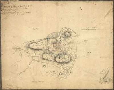
Ensign Henry DeBerniere was an officer in the 10th Regiment of Foot in 1775. An enterprising indivual, with a talent for map making DeBerniere had undertaken "spy missions" in 1774 mapping routes out of Boston. He took part on the 19 April mission to Concord to destroy the supplies gathered there. He also made a series of maps of Boston and the surrounding areas. These included distances marked between tiwns, good tactical positions and possible places for encampments. One of his best maps is of the Charlestown Peninsula and British troop movements during the Battle of Bunker Hill. This adds greatly to our understanding of the battle.
There are a couple editions of this map on the internet. Most are of later printed editions of his map. These were professional engraved editions. Unfortunately these often changed the ground scale and often many details. Here is an 1818 edition done in Philadelphia.
In the Geography and Map Division Library of Congress ( G3764.B6S3 1775 .B3 Vault) and is an excellent copy of his actual drawing. The details of the map are outstanding and super useful to students of the battle or miniature wargamers wishing to refight the battle historically. The topography is detailed, to include marshy ground and elevations.
This enlarged section showed the area where the Howe landed his main force at Moulton's point; sent his light Infantry companies along the beach to turn the American flank and the Grenadier attack against the rail fence. The numerous fences slowed the British advance, and exposed them to small arms and cannon fire while trying to cross them. The Royal Artillery could not cross the fields due to these fences so went a round them and got stuck in the wet marshy ground at the base of Breeds hill. The routes of the 5th and 52nd regiments during the third attack are clearly marked.
A close up of the Light Infantry companies on the beach trying toout flank the American position along the rail fence. This area today is near the present Charlestown High school and still has a sharp drop which obscure it from the ground. The order of march for the light Infantry are (from left to right) 23rd, 4th, 19th, 52nd, 43rd, 65th, 59th, 47th, 35th, 38th and 5th.
The final assault on the redoubt and breast work on Breeds hill. This is one of the very few maps which show how close Charlestown was to the hill and how snipers there effected earlier attacks. It also points out the barn which had to be taken before the final attack on the redoubt. Again fascinating details here like the extra flank companies position with the Marines and 47th regiments.


Extraordinary! Thanks for sharing this Mark. I've never seen this map before.
ReplyDeleteEric
There is an amazing amount of detail in the map which is left out of later engravings. One thing I missed until one if my walks from the navy yard to the rail fence area (path the Grenadier battalion took) is it is slightly up hill. (Very much like the field at Freedman's farm at Saratoga.) So its uphill and then crossing all those fences. The last one under fire. Now you start to understand why the Grenadier battalion suffered the heaviest casualties that day.
DeleteThis is really excellent detail on one of the best "known" battles in western history!
ReplyDeleteFor such a well know battle its surprise how little most Americans know about it. After one of my talks at the monument one tourist came up to ask a questions. He wanted to know if General Robert E. Lee or U.S.Grant fought here!!???
DeleteAmazing maps, Mark!
ReplyDeleteThank you Ray! Its an excellent source for setting up a game and your table top.
Delete