
There is very little today of the Sudbury Fight. The area has been built over but there are a number of markers where buildings were located. The site of the Green Hill fight is now a very upscale and crowded neighborhood who's people will get rather upset with you if you tramp through it near or on their land. And the Sudbury police just want to test you for drinking or drugs if you explain you are looking for the 1676 battlefield. The Sudbury river has been famed and tamed and the wet lands filled in and cultivated. In other words it looks nothing like it did in 1676.
But if you know where to look it can be a fun day. The text description here is from the book "King Philips War: The History and Legacy of Americas forgotten conflict. ". This is a outstanding book. Good summary of the war and individual battles. If you want to trace the battlefields and what is located there today thus book tells you. Highly recommended!
Haynes Garrison house;


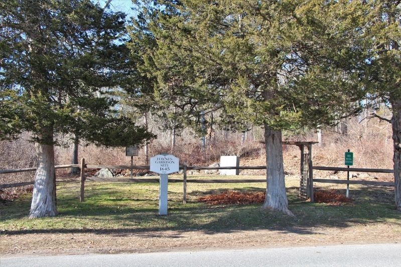
The site of the Deacon Haynes garrison House is on Water-Row Road, about two-tenths of a mile north of Old Sudbury Road (Route 27). The house was situated about fifteen yards from the road, facing south. It survived the Sudbury Fight, only to be demolished sometime after 1876. The cellar hole of the garrison is still visible.
John J. McCann, a Sudbury resident who was born in the Haynes garrison in 1860, remembered that “the rooms on the second floor toward the hill were bricked about four feet high, between the outer and inner walls” to keep the Indians from shooting those sleeping."
Goodenow Garrison House:

A state marker at the intersection of Old County Road and the Boston Post Road (Route 20) designates the site of the Goodenow garrison. The marker reads: THE GOODENOW GARRISON HOUSE PORTION OF THE GOODENOW GARRISON HOUSE IN WHICH SETTLERS TOOK REFUGE FROM KING PHILIP’S INDIANS DURING THE BATTLE OF APRIL 18–21, 1676. The house was standing as late as about 1815, but was moved or destroyed shortly thereafter.
Noyes’ Mill:

The site of Noyes’ Mill is marked on Route 20, west of Concord Road, near the present-day Mill Village shopping center. The marker reads: HOPBROOK MILL TO THE LEFT IS THE SITE OF HOPBROOK MILL, ERECTED IN 1659 BY VIRTUE OF A TOWN GRANT TO THOMAS AND PETER NOYES, “TO BUILD AND MAINTAIN A MILL TO GRIND THE CORN OF THE SETTLERS.” IT IS NOW THE PROPERTY OF HENRY FORD.
Sudbury Fight Marker and Green Hill Fight:

Wadsworth, Brocklebank, and twenty-seven of their men were buried in a mass grave described by Alfred Serend Hudson as about six feet square “in which bodies were placed in tiers at right angles to each other.” The spot was marked by a heap of stones, in part to deter wolves. In 1852 the remains of these men were excavated and moved fifty feet north to the site of a new monument. A state marker at Boston Post Road (Route 20) and Concord Road designates this memorial, which is four-tenths of a mile north on Concord Road at the Wadsworth Cemetery. The marker reads: SUDBURY FIGHT ONE-QUARTER MILE NORTH TOOK PLACE THE SUDBURY FIGHT WITH KING PHILIP’S INDIANS ON APRIL 21, 1676. CAPTAIN SAMUEL WADSWORTH FELL WITH TWENTY- EIGHT OF HIS MEN. THEIR MONUMENT STANDS IN THE BURYING GROUND.
The Wadsworth Monument and Grave:

The monument itself sits toward the back of the cemetery and reads: THIS MONUMENT IS ERECTED BY THE COMMONWEALTH OF MASSACHUSETTS AND THE TOWN OF SUDBURY IN GRATEFUL REMEMBRANCE OF THE SERVICE AND SUFFERINGS OF THE FOUNDERS OF THE STATE AND ESPECIALLY IN HONOR OF CAPT. S. WADSWORTH OF MILTON CAPT. BROCKLEBANK OF ROWLEY LIEUT. SHARP OF BROOKLINE AND TWENTY SIX OTHERS, MEN OF THEIR COMMAND, WHO FELL NEAR THIS SPOT ON THE 18 OF APRIL 1676 WHILE DEFENDING THE FRONTIER SETTLEMENTS AGAINST THE ALLIED INDIAN FORCE OF PHILIP OF POKANOKET 1852
Samuel Wadsworth’s stone, set up in 1730 by his son, Benjamin (then president of Harvard College), was moved with the bodies to the base of the new monument. It reads: CAPT. SAMUEL WADSWORTH OF MILTON, HIS LIEU. SHARP OF BROOKLINE, CAPT. BROCKLEBANK OF ROWLEY, WITH ABOUT TWENTY-SIX OTHER SOLDIERS FIGHTING FOR YE DEFENSE OF THEIR COUNTRY WERE SLAIN BY YE INDIAN ENEMY, APRIL 18TH 1676, & LYE BURIED IN THIS PLACE
This is a very interesting series, Mark, on a conflict I know little about. Thank you!
ReplyDeleteThank you for the very kind words. Its a interesting period.
DeleteAs Jonathan has said, a nice series of posts on a conflict that receives very little coverage, certainly on this side of the pond.
ReplyDeleteI have a couple more posts in the works. One a reading list and another on combatants.
DeleteReading the same book and about to go out looking for a site on Arrowsic Island, Maine. A fortified trading post was carried due to a picket leaving the gate unlocked.
ReplyDeleteDuh! I thought you closed the gate!
ReplyDeleteGreat intro to a fascinating period of history I knew next to nothing about, so I’ve started reading a bit more. Which is probably dangerous... 😆
ReplyDeletealways dangerous reading about a new period. Janine asked me the other day when do the miniature figures start arriving!
Delete...but I already have the terrain!
DeleteAnd I just ordered figures.....
DeleteJust saying.....